Posted tagged ‘Thematic Maps’

T.I.A: This is Africa! From Algeria to Seychelles

August 22, 2011

Last week our Maps team at MapsofWorld.com developed two more thematic maps on the African Continent. These thematic maps come as handy resources to students, teachers and researchers. On our website you can find a staggering collection of physical maps, political maps, blank maps, outline maps and thematic maps.

The two maps we’ve added to our collection:

Your Comments?
What kind of thematic maps do you want us to develop? Let us know in tweets, facebook wall updates on comments below.

Wall Maps?
Our ‘Back-To-School’ offer is running on our Maps Store for US; Be sure to check out the deals if you are looking for a wall map for your room or office.

Initiative to Change Time Zone, USA – Will South County, Dakota be successful?

March 8, 2010

As a huge and expansive country, USA is coordinating its time schedule with six standard time zones along with a seventh time zone covering the Puerto Rico region and the US Virgin Island. Still intermittent problems persist within certain areas of USA who have recently expressed their wish to opt for a change in time zone.

Stark County, North Dakota has initiated the process of proposing a time change from the existing Mountain Time Zone to Central Time Zone (CST/CDT), through which the county would be in par with major areas of North Dakota, almost throughout the year. A time zone such as this means the Stark County government offices, health care organization and private business which need to coordinate their activities with those external to the county will be able to function better and more effectively.
Consensus on this issue is being sought about by inviting support from nine south-west counties through ballots and petitions, though feelers of disinterest have been more prominent. Yet all is not lost, as most counties have expressed their wait and watch motive over the South County’s change in the time zone proposal.


At present, Principal time zones in the US are as follows:
1. EST or Eastern Standard Time Zone – followed by the states on Atlantic coast & eastern Ohio valley
2. CST or Central Standard Time Zone – followed by the Gulf coast, Tennessee Valley and Great Plains
3. MST or Mountain Standard Time Zone –followed by the Rocky Mountains
4. PST or Pacific Standard Time Zone – followed by the states on the Pacific coast including Nevada
5. AKST or Alaska Standard Time Zone – followed by the non-contiguous states of US
6. HAST or Hawaii-Aleutian Standard Time Zone – Hawaii and the portion of Alaska’s Aleutian Islands west of 169° 30′ W longitude
7. Atlantic Time Zone – followed by the Puerto Rico region and US Virgin Island

All of the Standard time zones are defined in terms of offsets from UTC or Coordinated Universal Time.

Log on to US Map to make the most of vast depository of USA maps available as a ready reckoner. Ranging from general reference USA Maps, USA States Maps, USA Thematic Maps, USA city maps, digital USA maps and lots more, you will certainly find them of great use.

Calendar 2010 – A tribute to the world

March 4, 2010

Calendar 2010…..this year MapsofWorld has dedicated its calendar towards ‘Our World’. Well, this does make sense as ‘Our World’ in entirety is the focal point of us as humans as well as for Mapsofworld.com.

We, Human beings as intelligent species of the world are inquisitive and curious to learn more, why, what and how of each and every happening in the world. This has further lead to the development of vast bank of database and information which has to be collated, stored and presented in manner which serves its very purpose. Thus maps have evolved as a pictorial representation of the information related to the world and human existence within it.

Calendar 2010 takes you across each and every continent throughout the year, reminding us how lucky and grateful we are to live in this wonderful world. Our entire life journey begins here and ends here as well. Progress and development have made it possible to cross geographical barriers and reach far off and distant places either virtually or physically in the shortest time span possible.

Maps exhibited in the calendar depict even the minutest physical features of the world, with the most interesting being the depiction of ocean bathymetry in these maps. North America, Asia and Antarctica maps are few key highlights of this cartographic ensemble.

As a gentle reminder of the greatness and the magnitude of the world, through Calendar 2010, Mapsofworld pays a tribute to the world which belongs to one and all.

World Maps

February 26, 2010

Information collected and disseminated in special ways is the right way to increase the worth of information. It is utmost essential to provide information in the right manner and context so that its value increases manifold and it serves its due purpose.

The world and its issues gain complex face and features, hence, the information and data required is also different and special as per the requirements of the subject. Taking into consideration the diverse features and requirements, MapsofWorld.com has dedicated a very special section of World Maps.

World Maps available throw light on topics related to Business and Economy, Climate, Energy, People, Travel and others as main categories. This section is highly useful amongst researchers, scholars and even the business community alike who wish to venture into new businesses.

All of us know before making any major decision, it is imperative to accumulate an in depth overview of all factors influencing the decision – be them geographical factors, demographic factors, historical or social factors. Through the varied form of world maps it becomes extremely easy and convenient to retrieve the suitable information in order to arrive at a concrete decision in a highly logical and well phased out manner.

For e.g. World Projection Maps are used to depict the surface of the earth on a flat surface. Depending on the purpose of use these accurate and specialized projection maps, provide to be a valuable resource in purporting your case in the right direction and in the right manner.

World Map Viewer with up-to-date Country Facts

February 19, 2010

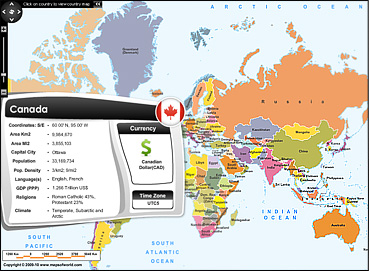
Avid Internet users already know how fast web pages provide with relevant information. The best example of this can be the world map viewer application, which is just what you could wish for when looking for a quick snapshot of a particular country. World Map Viewer, an interactive map based application comes with a unique feature of providing vital information and statistics of countries of the world.

On mouse over a particular country you can view country details beginning from its coordinates, area, population, capital city, climate, language, religions followed and so on.


Also, on the right hand corner you can view the flag, Time Zone and the currency symbol of the country. You can even click the countries and browse through varied maps ranging from physical, outline, state, river, travel, etc.

Designed with this specific intent in mind, the world map viewer is going to be frequently used by most visitors on maps of world.